Canada Map

Request Free Visitor Guides

The Lost Mine Trail

Basics
Length:
4.8 miles
Difficulty:
Intermediate
Elevation Range:
5600 feet to 6850 feet
Elevation Change:
1250 feet

Description

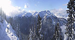
The Lost Mine is accessible by a tricky, steep trail up the mountains.

Details

Length:
4.8 miles
Difficulty:
Intermediate
Elevation Range:
5600 feet to 6850
Elevation Change:
1250

Map + Directions

Basic Directions
Begins at mile marker 5, along the Basin Road.

Copyright © 1997 - 2024 The Go Travel Sites. All Rights Reserved and.

Email Page Link

Complete the form below to email this page to a friend or family member's email. You can send yourself an email as well. Your email and your recipient's email will NOT be shared with anyone. See our full Privacy Policy for details.
:
:
:


:
Copy Yourself on the Email Yes No
:
:

1

Select a Free Visitor Guide below

2

Complete the form to receive your guides by mail
Bellingham Whatcom County Bellingham Whatcom County Bellingham Whatcom County
Canadian BorderWe offer a break from the ordinary. With magnificent natural scenery, skiing and snowboarding at Mt. Baker, hiking, arts and theatre, charming villages and water adventures like whale watching – Bellingham Whatcom County is a unique area of Washington state. Visit our website to plan your trip.
Request this Free Visitor GuideRequested! You're all set! Complete the form below to receive your guides by mail.